
|
|
Home | Photo Gallery | Tramping Tips |
| Prologue | Diary | Route Maps |
 |
 |
 |
| Date: |
Tuesday 4 February 2003 |
| Location: |
Sydney - Christchurch |
| Details: |
I woke up this morning at 5:10am thinking it cant already be time to get up. Outside it was still dark. I drove to the station, but missed the train I intended to catch because I thought it was a Northern line one. I caught a north shore train (the one after I intended). During the trainride, I saw my first sunrise in a long time. As the train pulled into the domestic terminal station (just before the international terminal), I could clearly smell jet fuel.
At the moment, I am over the Tasman sea, looking out at the window at the deep blue sky above, the puffy white clouds far below, and the occasional glimpse of the sea through the clouds. Over the last few days I have been feeling rather stressed about the trip but now I am in the air, I am feeling quite a bit more relaxed. Part of this is because I have already met a fellow traveller in the same situation as me. She is a young Asian woman going to New Zealand and it is the first trip for her also. Currently we are going at 866km/h and ar 11900m high, well over halfway to New Zealand outside it is a lovely -61°C!
|
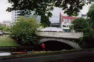
| Punt on the Avon in Victoria Square, Christchurch |
I made it! Im in Christchurch. Im sitting in a park (Victoria Square) on the banks of the Avon river. The rest of the flight was interesting, we were served a warm breakfast on the plane, which was at about 10:00. I had already had a muffin, but it sort of became my lunch. Approaching New Zealand, I could see the Southern Alps snow capped peaks from about 400km away! As we got closer, I could see Mount Cook and many other ice capped mountains poking through the clouds I can see why the Maori name for Mount Cook is Aoraki Cloud Piercer. I can also see why they call it Aotearoa The land of the long white cloud! The sea to the west of New Zealand was clear of cloud but just inland of the western coast, the clouds were piled up around the Alps. We flew directly over Arthurs Pass, and could see the sometimes cloud shrouded mountains and valleys. The mountain sides were mostly bare of vegetation a lot of scree. There were many rivers and several lakes. I could see lake Tekapo, and lake Pukaki. Descending through the clouds was somewhat bumpy, - once through, I could see a patchwork of fields green and brown, many bordered by rows of trees. We passed over another river just north of the airport which was similar to the others before a wide alluvial bed with many crisscrossing channels in it quite strange. This river, unlike the mountain ones had aquamarine cloudy water flowing in it. Touchdown was quite hard it even dislodged one of the oxygen mask panels, and made several people gasp. After having to have a hand inspection of my tent and boots, I got out of the fairly small airport and met the arranged bus to the Stonehurst backpackers. I dumped my main bag in the room since it has pretty good security keys for each room and a keypad for the entrance. There are apparently two others in the room but they were not there.
Wandering around Christchurch, it is almost identical to what an Aussie city of 300,000 would be. Lots of the same shops, same sort of feel. However, the Avon and the trams make it seem very civilised in a British sort of way. I forgot to mention the temperature! It was fine walking around, but sitting here now is getting rather chilly it was 16°C when I arrived a bit of a change from Sydney! The only rain Ive seen so far has been a little at Sydney airport thankfully. The Avon is a quite narrow (5-10m) river, very shallow and quite fast flowing. Every so often, a punt goes past, making it seem even more English. Ive now organised things till Friday thanks to a small independent travel agent and a phone card.
|
top | |