
|
|
Home | Photo Gallery | Tramping Tips |
| Prologue | Diary | Route Maps |
 |
 |
 |
| Date: |
Tuesday 4 March 2003 |
| Location: |
Kepler Track (Day 3) |
| Details: |
|
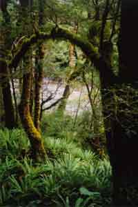
| Beautiful Ferns, Trees and River near Rocky Point |
There was snow all over the mountains surrounding the hut, and over the Murchisons opposite the hut it was very pretty. The wind had dropped to about half the strength of yesterday.
At 8:30am I was packed and ready to go whatever way was available. The hut warden came in and said the track was Ok to go but to expect snow drifts to be knee to thigh deep, and asked us to hang around to 10:00am since the weather was predicted to improve over the day. I went for a walk out to Luxmore caves, to kill some time till 10:00. Walking across the boardwalks and stairs when they were covered with up to 5cm of snow felt pretty dodgy. It was very lightly snowing, and the wind was really cold. The area was so pretty with the snow. The cave was completely unimpressive it was a hole in the limestone where a stream flowed into the caves you could walk about 20m without caving gear. Further in are some pretty nice caves, from what was shown in the hut. The entrance was just a smooth rock tube with water running along the bottom.
By 9:30am a couple of people had already left - I and several others decided to leave. The first hundred metres of track were clear of snow, but after that, there were only occasional sections without snow. It was still lightly snowing, and when I wasnt climbing, it was quite cold. Unlike all the other tracks Id done, the Kepler Track travels across the mountain ridgelines for most of a days walk (for about 12km). This is because the Kepler range is not extra high.
The mountains looked amazing with their cover of snow. The track climbed up around Mount Luxmore, finally reaching Luxmore Saddle The highest point on the track (1400m). There was an optional track to the summit of the mountain, but the snow clouds were surrounding the peak, and even the saddle was a whiteout. The track then descended (with some short ascents) to Forest Burn Shelter. I was walking through snow which was generally toe to ankle deep, but with occasional knee deep drifts. It was quite hard work to walk through, since the last part of a stride where you would normally use your toes to push off, caused your foot to lose traction. Also, there were rocks on the track, and drainage culverts running beside, and occasionally across the track which were often impossible to see under the snow. In places, 20cm icicles hung from undercut earth banks.
Halfway between the Forest Burn shelter, and the Hanging Valley shelter, there were some nice views of the valleys and opposite mountains to the north and south. At one point there was a nice rainbow, and at another, I was walking along a knife edge ridge. I was using my video camera at one point and because it was snowing, I couldnt have it attached to my pack. The wind caught the camera case, and it started going down the slope, away from the track. Without thinking, I dived for it, caught it, but found myself sliding about four metres down the slope. Carefully I was able to climb back to the track. Unfortunately my video camera also hit the snow. I was however able to blow almost all of the snow off it immediately.
Eventually I got to the second emergency shelter Hanging Valley shelter. Like the first, it was a strong, small, one room shelter with nothing in it. After this, the track seemed to be less trodden down and harder to see. The track descended a ridgeline fairly slowly. There were several sets of stairs, all covered with 10cm of snow. They felt rather dangerous. All structures (stairs, boardwalks and bridges) in national parks in NZ are either metal (for swing bridges) or are wood covered with chicken wire. The chicken wire is great in rain for improving grip, but no help at all in snow.
Far below the ridge, I could see the Iris Burn valley, it was quite pretty. Soon the track came to the point where the ridgeline met the bushline. From here, the track was no longer snowy, as it plunged off the ridge, down the side into the valley. There were an enormous number of switchbacks as the track descended, but even so, it was fairly steep it was often easier to jog than walk.
Pretty soon, the track started going past small creeks. The falling snow had turned to rain at the bushline, and it made the greens of the forest jump out, especially the ultra lush areas around the creeks. It was very nice. The track descended into the valley for what seemed like ages, at one point following a creek for a while, then more switchbacks.
Suddenly the track flattened out, and right there was a clearing with the Iris Burn Hut. I got there about 1:20, well short of the 6 hours estimated. The hut was in a beautiful location, looking up a valley with a great waterfall not far away. The hut was again well set up, but I was thinking I would be able to make it to the next hut today, which would allow me to complete the entire circuit, rather than get out at the Rainbow Reach swing bridge.
After thinking about it for half an hour, I decided to go on my only worry was whether there would be room at the hut, but I figured the closure should have reduced the numbers there, and increased them at Iris Burn. I started walking at 1:50, the track went slightly up and down, through the beech forest, and soon came to the Big Slip a landslip which had levelled all trees and plants in a huge area probably a square kilometre. It happened in 1984 and must have been awesome to see. The route guide I had showed the slip about a quarter of the way to the next hut , but it was way out.
Following the Iris Burn, the track seemed to take ages to reach Rocky Point. Fortunately the weather had improved since the Iris Burn Hut it stopped raining, and the sun came out! By the time Id got to Rocky Point, my feet and upper leg muscles were getting a bit achy Id also run out of water, since Id forgotten to refill at Iris Burn Hut.
|
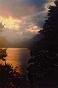
| Lake Manapouri at Sunset from Motarau Hut |
The track followed the Iris Burn for about 1 ¼ more hours, at one point it ran along the wall of a small canyon, but was always in lush beech forest. The Beech trees are interesting, their leaves are very small and almost circular, (less than 1cm diameter). They make a nice leaf litter for the track though. After another seemingly long time, there was a glimpse of the mouth of the Iris Burn where it flows into Lake Manapouri. The track immediately turned left to follow the lake shore around Shallow Bay. There were great views across the lake of distant sunlit mountains.
Shortly I came to the Motarau Hut what a relief, my feet and legs were very tired and achy. It has a great location about 20m from the beach on Shallow Bay, Lake Manapouri, with excellent views across the lake. The husband of the hut warden was there wandering around, and he informed me that I was the only one there tonight (and I was worried about there being room!) Upstairs there was a row of about 20 mattresses on a low platform I put by sleeping gear along it. I got to the hut about 5:30 34km walked in 8 hour, including breaks No wonder my feet and legs were aching. The hut warden came around 7:30 and we talked for about half an hour. She said that Iris Burn hut was going to have about 77 people, in a hut built for 50 That made me very glad Id continued. It was very quite in the hut with only me there I read some more of my book (Dale Brown Wings of Fire). The sunset was very nice. It was also nice being able to spread my gear everywhere without causing a problem.
|
top | |