
|
|
Home | Photo Gallery | Tramping Tips |
| Prologue | Diary | Route Maps |
 |
 |
 |
| Date: |
Sunday 2 March 2003 |
| Location: |
Kepler Track (Day 1) |
| Details: |
|
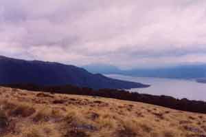
| View North from the Kepler Track near Luxmore Hut |
Kepler today. After sleeping in a little, I stored my excess luggage with the hostel, and went into town – I had to get some breakfast, and sort out onward travel and accommodation to ensure I got to Christchurch in time for my flight home. I stopped in at the DOC office as well and got another copy of the track description – I’d lost the one I’d got previously. I also thought I’d have to fill out an intentions form, but apparently you don’t need to for the great walks – I wonder how they know when to mount a search?
The track from the DOC office round to the start of the Kepler track took about 45 minutes to walk, and went through the bird sanctuary area I’d seen before, and around the southern end of the lake. There were nice vies across the lake, although was cool and overcast.
Lake Te-Anau is part of a hydro power system which includes Lake Manapouri. It is however a very special system, since it does not affect the levels of the lakes. To do this, the hydro power station was built far underground near Lake Manapouri. To keep the lakes at their natural levels, control gates were built on the outlet point of lake Te-Anau. These control gates are where the Kepler track starts. Huge volumes of water swirl through the gates to form the Waiau River.
The track immediately plunges into the beech forest which lines the western shore of Lake Te-Anau. The forest is tall and lush, but has very little undergrowth. It was strange to see trees and moss growing right down to the waters edge – Australia has virtually no natural fresh water lakes. Unfortunately there were several boats driving past the area, which somewhat spoiled the tranquillity – why can’t they make boats as quiet as modern cars?! The track was flat until Brod Bay, where I stopped for a few minutes to look at the views across the water.
The days climb started immediately on leaving Brod Bay. I ascended through more beach forest, sometimes with ferns or small trees as undergrowth. The climb started gently – I was able to keep a good pace, but nearing the limestone bluffs, became steeper and steeper – there was no wind and I was quite hot and sweating. It spotted a few drops of rain on the way up. A little way above the bluffs, the trees were covered in hanging lichen – there was much more lichen than leaves on most trees here.
Straight after this, the track burst out from the forest, giving great views of the area to the east, including the lake, the town, and many mountains. The track above the bushline was slightly up and down, giving great views of the surrounding mountains, including the Murchison Mountains, and the lake.
After about 45 minutes of walking above the bushline, I came around a corner and there was Luxmore Hut. It’s pretty big – 50 trampers and a hut wardens quarters. It is well set up, and has a great outlook onto the Murchisons. I set up my bed, (you have to do this with shared accommodation, so you can easily go to bed, even if others are already asleep).
The hut warden (Jenny) ran a daily “Interpretive Nature Walk” at 6:00 each evening. Surprisingly, since it was spotting rain, there were about 10 people who turned up for it (including me). We went out on a short circuit, where Jenny pointed out various plants and talked about the animals. We looked at an area of tussock (curly leaf snow tussock), there were other low woody bushes there too, along with daisys and other flowers. We then looked at an alpine bog where there were many types of moss, and other ground cover, including some sundews. (They were different to the type I saw on the Milford).
At 7:30, back at the hut, Jenny gave the evening talk – Fire safety, kitchen use, weather – then she collected the hut passes. The weather for tomorrow was looking bad – there would be a weather update at 8:30, we were asked not to leave till then.
|
top | |