
|
|
Home | Photo Gallery | Tramping Tips |
| Prologue | Diary | Route Maps |
 |
 |
 |
| Date: |
Tuesday 25 February 2003 |
| Location: |
Milford Track (Day 1) |
| Details: |
|
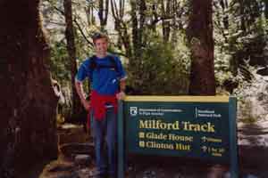
| Me at the Start of the Milford Track |
The day of the start of the Milford Track. I got up with the others - 7:30 and packed the things on the gear list into a plastic bag, and the rest into my duffel. I stored the duffel with the hostel, and went to DOC and booked the Kepler for 2/3/03. Then I went to the Holiday Inn where the Milford Guided Walks office was, for the 9:30 briefing. The briefing was mostly stuff Id already read. I then got a small (40Litre) pack, bedsheet and map, and packed my gear. Lunch was to be at 12:00 when the people from Queenstown arrived There were 4 other people at Te-Anau an older English woman, a fairly young Japanese Woman and a young couple from the USA. The rest would come from Queenstown 45 of them. I wandered around for a while got some breakfast, used the internet, etc.
At 12:00 I went to the Holiday Inn restaurant, and the five of us started lunch About 10 minutes later, the others started coming in I was about the youngest as far as I could tell there were two or three others around my age. Lunch was nice, and soon we were outside lining up for a group photo, then piling onto the bus they have at least two busses dedicated to the Milford, and another two for the Routeburn. We drove up lake Te-Anau, but away from the shore, heading toward the snow capped peaks in the distance to the north. After about half an hour, we came to Te-Anau Downs I dont know if there is a town there all we could see was a wharf. Docked there was the Fiordland Express a big catamaran formerly used on the Foveaux Express route.
We boarded and I went to the open air top deck. The views from the dock were great, but got much better as we started the cruise to the head of the lake. The boat ran at 22 knots which was pretty fast when you were exposed to the airstream it was a little cold, even though there was not a cloud in the sky, and the sun was rather warm. In places, the lake looked almost as smooth as a mirror, elsewhere, it was blown by strong westerlies. The mountains surrounding the lake grew taller and taller, with more snow on the tops. We passed by Mackinnon memorial on a tiny island near the head of the lake, and also saw some caves which had been inhabited by early Maori. Soon we came to the head of the lake where there was a small wharf. This was after passing several fiords which entered the lake from the west. They were quite beautiful.
After docking, and grabbing our packs, we took some photos at the sign for the track start. There was a group of Japanese women who were all over 50 (some 70 years) on the boat and they were doing exercises next to the wharf as I set off into the beech forest. I was almost immediately alone all the others had already left except for the Japanese group. The walk was only 1.6km to Glade House and it was over in minutes it followed the Clinton River for a short way, then headed up to the house. The track was lined with trees which had lichen hanging all over them. Glade House sits in a natural clearing next to the Clinton River. It is quite large and is third one to be put on that site ( the others having been destroyed). It is only 1 mile from the end of the lake, because in the very early days, sometimes it would take all day to sail to the head of the lake. Sometimes they couldnt sail, and had to trek eight hours over Dore Pass to reach the house. The rooms in the house had 4 beds (2 bunks) with communal bathrooms for the shared accommodation. There was flush toilets and hot showers. We were met with biscuits, juice and water.
Soon we were mustered for a nature walk in the area around Glade House. We spent about 45 minutes walking through the beech forest, with Scott the guide pointing out all the different types of plants. We stopped at the Glade Burn (Burn is a word for a small creek). This is the river that supplies the water for Glade House. What had surprised me at the briefing was that they said if you run out of water, just re-fill from the fast flowing part of any stream. This is sort of what Id done in Arthurs Pass, but Id chosen side streams carefully. We walked back down to the bottom of the hill after spending about half an hour at the creek. There were some nibbles laid out when we got back which were quite nice, and then we had dinner, which we had chosen earlier in the day it was very nice three courses. We then had tea & coffee and sat down for the briefing. Before the briefing, we did an introduction session we got up country by country and introduced ourselves. Each country group also had to sing a song we, of course, sang Waltzing Matilda but half of us were confused since we only sang a chorus. The Japanese ladies were funny most could only speak a few words of English. - They had a co-ordinator/interpreter with them. The briefing consisted of Scott getting up with a slide machine, and showing and telling us what we were in for the next day. Soon after this people prepared for bed, since the generator was turned off at 10:00. I stayed outside for a while after and looked at the stars.
|
top | |